Hydraulic modeling is one of the basic tools that engineers use to analyze the behavior of surface water in rivers, ditches, and floodplains. Thanks to the specialized HEC-RAS software, developed over many years by the Hydrologic Engineering Center of the US Army Corps of Engineers, it is possible to model phenomena related to water flow, which greatly facilitates the proper design of hydrotechnical structures, as well as railways, roads, and infrastructure facilities.
Quick links
HEC-RAS allows you to simulate steady and unsteady flows in one-dimensional (1D), two-dimensional (2D), and – in certain applications – three-dimensional (3D) systems. Experience in selecting the right approach is crucial: different models are used for large river systems and for local structures such as bridges, culverts, or weirs.
1D model – simple and effective
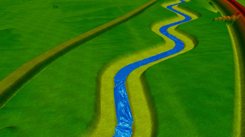
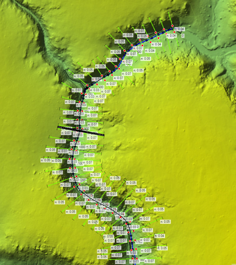
The 1D model is based on the description of flow along the axis of a river channel or canal. The calculations involve solving a one-dimensional stream energy equation (for steady flows) or Saint-Venant equations for slow-changing flows. The HEC-RAS software performs simulations through a series of cross-sections distributed along the watercourse.
Advantages of the HEC-RAS one-dimensional model:
- Speed of calculation – one-dimensional models require little computing power and relatively short simulation times.
- Lower data requirements – all that is needed is a good knowledge of the channel geometry, a few cross sections, and basic information about roughness (e.g., Manning’s coefficient).
- Application in large catchments – for analyses of large catchments, the 1D model is practically the only sensible option.
Limitations:
- Simplification of space – the program calculates a single water surface position for each cross-section. The actual variation in flow in the floodplain is ignored.
- Requirement to know the flow path – the user must specify the direction of water flow in advance, which is not always possible in flat areas or extensive river valleys.
- Limited ability to map objects – such as bridges, embankments, or complex weir systems.
The 1D model is ideal for steady-state flow analysis, long-term river network simulations, and flood forecasting for large areas.
2D hydraulic modelling – realism and accuracy of calculations
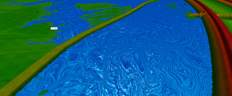
The 2D model introduces analysis in two spatial dimensions – in the horizontal plane (xy). Calculations are based on dividing the terrain using a mesh, and water flow is calculated in each of the elements. HEC-RAS allows the simulation of water flow in the riverbed and valley using a digital terrain model (DTM). Unlike 1D modeling, where flow is analyzed along cross sections of the river, 2D modeling allows for a more detailed representation of flow dynamics, taking into account changes in velocity and depth along the floodplain.
Advantages of 2D models:
- No need to know the flow path – water can spread in any direction, according to the energy of the flow.
- Precision – the 2D model allows for phenomena such as stream contraction and expansion, eddies behind structures, and changes in the water table in the terrain.
- Better representation of objects – bridges, culverts, flood embankments, and weirs.
- Specialized applications – analysis of floodplains, embankment and dam failures, flow modeling in urban areas.
Limitations:
- High data requirements – a high-resolution digital terrain model is necessary, which also takes into account the geometry of the riverbed.
- Time-consuming – calculations are much slower and calibration is more complicated.
- Hardware requirements – for large areas, HPC (High Performance Computing) or cloud solutions may be necessary.
The 2D model is particularly well suited to mixed flow regimes, such as during flood surges in flat areas, when water overflows flood barriers, floods cities, and spreads across floodplains.
3D flow simulation – where precision is essential
3D models are mainly used in scientific research and in the design of hydrotechnical structures. Unlike 1D and 2D models, they allow the analysis of vertical velocity gradients, turbulence, and vortex formation.
Advantages:
- Highest accuracy – they take into account all components of flow velocity and three-dimensional phenomena.
- Indispensable in design – e.g., bridges, weirs, dam structures, where it is critical to know the detailed effects of water on the structure.
Limitations:
- Enormous computational requirements – require supercomputers or specialized computing clusters.
- Costliness – the preparation and calibration of 3D models is a job for specialized teams.
- Time-consuming – preparing the model and performing the simulation takes a long time.
Criteria for selecting the HEC-RAS hydraulic model
The selection of the appropriate hydraulic modeling approach depends on:
- Spatial scale – large rivers and basins are best modeled in 1D, local floodplains in 2D, and structural elements in 3D.
- Analysis objectives – spatial planning and flood forecasting can be based on 1D models; bridge and weir design often requires a 2D or 3D approach.
- Input data – if an accurate digital terrain model is available, it is worth using 2D analysis; if only cross-sections are available, 1D will be better.
- Expected accuracy – quick forecasts require simpler models, while water quality or detailed turbulence studies require full 3D models.
HEC-RAS as an industry standard
HEC-RAS includes modules for building one-dimensional and two-dimensional models. The program allows you to simulate steady and unsteady flows, hydraulic calculations, water quality, and even debris transport. With the GIS interface and the built-in RAS Mapper tool, you can create detailed flood maps and visualizations of floodwater spread.
HEC-RAS software also allows you to take into account boundary conditions, changes in water level, energy losses due to friction, and flow contraction. HEC-RAS can handle all flow regimes, from calm to turbulent, and allows you to design hydraulic structures taking into account real hydraulic phenomena.
It is worth noting that HEC-RAS is available free of charge. This is important in the context of the new approach of PGW Wody Polskie, which clearly communicates its intention to move away from the MIKE family of software towards solutions such as HEC-RAS
HEC-RAS hydraulic modeling
- 1D models – fast and less demanding, good for large catchment areas and long-term analyses.
- 3D models – specialized and demanding, used in detailed studies.
In engineering practice, a hybrid approach is often used – a combination of 1D and 2D models to optimize both calculation time and prediction accuracy.
HydroBIM – your partner in hydraulic analysis
At HydroBIM, we specialize in creating digital hydraulic and hydrodynamic models using 1D, 2D, and 3D methods. We develop analyses of water flow in riverbeds and river valleys, simulations of floodplains, and assessments of the impact of hydrotechnical structures – from bridges and culverts to weirs and flood embankments.
Our team uses the latest capabilities of the HEC-RAS system and other tools, such as HEC-HMS and Scalgo, to support the design and implementation of infrastructure investments.
If you are planning a project that requires flow analysis, retention, or flood risk assessment, contact us. We will prepare a reliable study that optimizes your design and investment process.
About HydroBIM

HydroBIM sp. z o.o. is a specialized subcontractor in the hydrotechnical and hydrological industry for large infrastructure projects. Our clients include leading Polish and international design offices and consulting companies, such as AECOM, Sweco, EGIS, and Systra.
Our portfolio includes tasks within the Flood Protection Project in the Odra and Vistula River Basins (POPDOW) and the Central Communication Port (CPK).
We are a member of the Polish Association of Designers and Engineers (ZOPI).
We invite you to follow the company profile of HydroBIM on LinkedIn
HydroBIM sp. z o.o. is a specialized subcontractor in the water engineering and hydrological industry for large infrastructure projects. Our clients include leading Polish and international design offices and consulting companies, such as AECOM, Sweco, EGIS, and Systra.
Our portfolio includes tasks within the Flood Protection Project in the Odra and Vistula River Basins (POPDOW) and the Central Communication Port (CPK).
We are a member of the Polish Association of Designers and Engineers (ZOPI).
We invite you to follow the company profile of HydroBIM on LinkedIn and to work with us.