In common understanding, drainage is associated with drying. This is a misconception, as drainage facilities are used to regulate water relations in the soil through irrigation or drainage of the area. This improves crop growing conditions, increases agricultural productivity and protects against excessive moisture and flooding.
The State Water Management Authority (Państwowe Gospodarstwo Wodne Wody Polskie), responsible for national water management, has made a strategic decision to verify and update data on drainage equipment and drained land. This project is being implemented with funding from the National Recovery Plan (KPO).

What’s next for GeoMelio?
The newly created PGW Wody Polskie has, in a sense, ‘inherited’ the GeoMelio system, an electronic tool created to keep records of water drainage facilities and drained land. This system enables the collection, processing and analysis of spatial data related to drainage infrastructure. In theory, it was supposed to be a modern knowledge base on the condition of this infrastructure. In practice, however, it turned out that the system contained many gaps, inconsistencies and unverified information from various sources, often based on outdated paper documents.
Therefore, a decision was made to conduct a thorough verification of the data in the field. The project covered 15 river basin management authorities throughout Poland.
Objective: data organisation and digitisation
The aim of the project is to collect and verify in the field current data on drainage facilities – ditches, culverts, wells, sluices, drainage systems and even watering places and aqueducts. An individual technical data sheet is created for each facility, containing information on its location, technical characteristics and condition. This data is fed into a digital database, enabling further spatial analysis, maintenance and investment planning, as well as sharing information with local authorities and other stakeholders.
An additional element is the creation of high-resolution ortho-photo maps and longitudinal profiles of inventoried ditches.
Technical challenge and support from HydroBIM experts
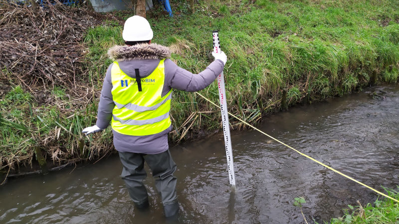
The implementation of the project requires significant organisational and technological resources. Surveying teams, supported by specialists from external companies, work in the field using advanced measuring equipment and GIS software. As part of the cooperation, the project partners are responsible for data collection, analysis of the technical condition of the structures and their digital mapping.

Specialised entities from the hydrotechnical industry are also involved in the project, including HydroBIM, which supports surveying teams in the technical assessment of equipment. Our role is based on our experience in water infrastructure analysis and our ability to work with spatial data and digital models. What’s more, as you can see in the title illustration, our engineers are not only at home in the digital environment.
The importance of the project for water management
Updating and digitising the register of drainage equipment brings a number of benefits. Firstly, it enables better planning of maintenance and modernisation activities. Secondly, it allows for precise management of water resources on a local and national scale. Finally, it provides a foundation for future adaptation projects in the context of climate change, such as the construction of retention reservoirs, the re-naturation of watercourses and the development of green and blue infrastructure.
The new database will also improve cooperation with local authorities, farmers and other land users, who have often lacked access to up-to-date information on water facilities in their area.
The drainage facility inventory project implemented by Wody Polskie is an example of the rational use of European funds to modernise key infrastructure. The role of companies such as HydroBIM in this undertaking demonstrates the importance of involving specialised industry partners in the implementation of complex public projects. In the long term, this project has the potential to contribute to Poland’s resilience to the effects of extreme hydrological phenomena and to support the sustainable development of agriculture and rural areas.
Image source: archive HydroBIM